

A Home Assistant custom integration (HACS-ready) that shows the aircraft passing over a location you choose. For each flight it gives you the callsign, the departure and arrival airports, and a progress line showing how far along the journey the plane is: hours already flown, hours remaining, and total.
The bundled Lovelace card draws each flight as an origin → ✈ → destination track with hours, an estimated CO₂ footprint, and people on board (light and dark):
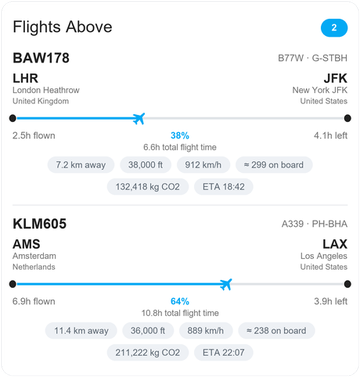
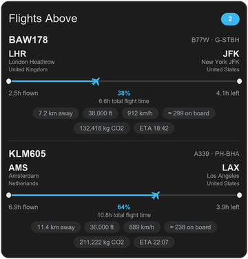
Turn on show_radar and it also draws a radar of every aircraft around you,
plotted by real bearing and distance:


All data comes from free, open community APIs: no account, no API key, nothing to pay:
| Purpose | Source | Cost |
|---|---|---|
| Live aircraft positions | adsb.lol → falls back to airplanes.live | Free, no key |
| Departure / arrival airports | adsbdb.com → falls back to hexdb.io | Free, no key |
Two route sources are tried in turn, so far fewer flights end up without a route.
Flight-hours are estimated from great-circle distances and a typical cruise speed for the aircraft type (these APIs don't publish scheduled times). Cruise speed is used rather than the live ground speed so a plane that is climbing or descending slowly doesn't read as a much longer flight than it is. Treat the times as a good approximation, not an airline timetable.
- In Home Assistant go to HACS → ⋮ (top right) → Custom repositories.
- Add the URL of this repository, category Integration, and click Add.
- Find Flights Above in HACS, click Download, and restart Home Assistant.
- Go to Settings → Devices & Services → Add Integration → Flights Above.
Copy the custom_components/flights_above folder into your Home Assistant
config/custom_components/ directory and restart.
When you add the integration you'll be asked for:
| Field | Meaning |
|---|---|
| Name | Friendly name (also used for the entity ids). |
| Latitude / Longitude | The address/point to watch. Pre-filled with your Home Assistant location. |
| Radius (km) | How far around that point to look (max 400 km; the ADS-B source caps the query at 250 nautical miles ≈ 460 km). |
| Number of flights (1-3) | How many of the most recent flights to expose as sensors. |
| Update interval (s) | How often to poll (default 60 s). Please keep it reasonable; these are free community APIs. |
| Only show flights with a known route | On by default: skips aircraft whose departure/arrival airport can't be identified, so you only see flights with full details. Turn it off to include every aircraft overhead (airports/hours/CO₂ left blank when unknown). |
You can change the radius, count and interval any time via the integration's Configure button.
Tip: to find the coordinates of any address, right-click it in Google Maps and click the lat/long numbers to copy them.
For an integration named "Flights Above" you get:
sensor.flights_above_flights_overhead: the true number of aircraft currently within your radius (not limited by how many flights are displayed). Its attributes include aflightslist summarising the tracked ones.sensor.flights_above_flight_1,_flight_2,_flight_3: one per configured slot, ordered by most recently seen. State = callsign.
Each flight slot sensor exposes these attributes:
| Attribute | Description |
|---|---|
origin_name / origin_iata / origin_icao / origin_country |
Departure airport + country |
destination_name / destination_iata / destination_icao / destination_country |
Arrival airport + country |
hours_flown / hours_remaining / hours_total |
Estimated flight time |
eta |
Estimated arrival time (ISO timestamp) |
progress_percent |
How far along the route (0-100) |
progress_bar |
●━━✈──● style bar for that percent |
route_line |
Full one-line summary (origin, bar, destination, hours) |
co2_total_kg / co2_so_far_kg / co2_remaining_kg |
Estimated CO₂ footprint for the whole aircraft |
emissions_class |
Aircraft class used for the CO₂ estimate (widebody, narrowbody, regional, turboprop, bizjet, piston) |
people_on_board / seats_typical |
Estimated people on board (typical seats × load factor) and the typical seat count for the type |
latitude / longitude / altitude_ft |
Current position |
ground_speed_kmh / heading / distance_km |
Movement + distance from your point |
vertical_rate_fpm / climb_status |
Climb rate and climbing / descending / level |
squawk |
Transponder code |
registration / aircraft_type |
Tail number and ICAO type code |
in_range |
Whether this slot currently holds a flight |
The integration keeps a 30-minute rolling history, so the slots keep showing the last flights that passed through even when the sky is momentarily empty.
CO₂ and people-on-board figures are rough estimates. CO₂ comes from the flight distance times an average fuel-burn factor for the aircraft class; people on board comes from the type's typical seat count times an average load factor (~82%, crew only for freighters). Good for a sense of scale and comparison, not exact figures.
The integration ships a graphical card that draws each flight as an origin → ✈ → destination track with the plane animated to its real progress position, plus hour labels and info chips.
 LHR ●━━━━━━✈──────────● JFK
 2.5h flown        38%        4.1h left
              6.6h total flight time
The integration serves the card file automatically at
/flights_above/flights-above-card.js and tries to register it as a dashboard
resource for you. If your dashboard is in storage mode (the default), it
should just work after a restart.
If the card shows as "Custom element doesn't exist", add the resource manually:
- Go to Settings → Dashboards → ⋮ → Resources → Add resource.
- URL:
/flights_above/flights-above-card.js - Type: JavaScript Module, then reload the browser (Ctrl/Cmd-Shift-R).
YAML-mode dashboards: add it under
lovelace: resources:inconfiguration.yaml:lovelace: resources: - url: /flights_above/flights-above-card.js type: module
type: custom:flights-above-card
title: Flights Above
entity_prefix: sensor.flights_above
Card options:
| Option | Default | Description |
|---|---|---|
title |
Flights Above |
Card header. Set to "" to hide it. |
entity_prefix |
sensor.flights_above |
Prefix used to find the _flight_1…N and _flights_overhead sensors. Change it if you named the integration differently. |
flights |
(auto) | Optional explicit list of flight sensor entity ids instead of using the prefix. |
count_entity |
(auto) | Optional explicit "flights overhead" count sensor. |
max |
3 |
How many flights to display at once. |
sort |
recent |
Order flights by recent (most recently seen) or distance (nearest first). |
show_details |
true |
Show aircraft type / registration and the info chips. |
show_empty |
true |
Show a "No flights in range" message when the sky is empty. |
show_radar |
false |
Show a radar of every aircraft in range around your location. |
select_seconds |
30 |
How long a plane tapped on the radar stays pinned before the list returns. |
Set show_radar: true to draw a radar around your location. Your position is the
centre, north is up, and every aircraft currently inside your radius is plotted by
its real bearing and distance (not just the ones listed below it):
type: custom:flights-above-card
title: Flights Above
entity_prefix: sensor.flights_above
max: 1
show_details: true
show_radar: true
The rings mark a third, two thirds, and the full radius you configured. Callsigns are labelled when six or fewer aircraft are in range, so it stays readable when the sky is busy, and each blip has a short line showing which way that aircraft is heading. Each time new data arrives the radar plays a sweep, like a real one, so you can see at a glance that it just refreshed (it respects your reduced-motion setting).
Tap a plane on the radar and the section underneath switches to that aircraft's
details instead of the usual list. It goes back to the normal list on its own after
30 seconds (change it with select_seconds), or tap the same plane again to switch
back straight away. If you tap an aircraft that is not one of your tracked flight
slots, you still get its distance, altitude, bearing and heading.
Show a single flight (e.g. the nearest one):
type: custom:flights-above-card
title: Flights Above
entity_prefix: sensor.flights_above
max: 1
show_details: true
show_empty: true
Add sort: distance to make that single card always show the closest aircraft
(by default the list is ordered by most recently seen):
type: custom:flights-above-card
title: Nearest flight
entity_prefix: sensor.flights_above
max: 1
sort: distance
Example with explicit entities:
type: custom:flights-above-card
title: Overhead now
flights:
  - sensor.flights_above_flight_1
  - sensor.flights_above_flight_2
count_entity: sensor.flights_above_flights_overheadEvery value is also available as a plain attribute, so a simple Markdown card works too:
type: markdown
title: ✈ Flights Above
content: |
  {% set count = states('sensor.flights_above_flights_overhead') | int(0) %}
  **{{ count }} flight(s) in range**

  {% for i in range(1, 4) %}
  {%- set e = 'sensor.flights_above_flight_' ~ i %}
  {%- if states(e) not in ['unknown', 'unavailable', 'None'] and states(e) is not none %}

  ### {{ states(e) }}
  {{ state_attr(e, 'origin_name') or '?' }} → {{ state_attr(e, 'destination_name') or '?' }}

  `{{ state_attr(e, 'route_line') }}`
  {%- endif %}
{%- endfor %}- Coverage depends on volunteer ADS-B receivers near you. Well-covered areas (Europe, North America, cities) work best; remote areas may see fewer aircraft.
- Route lookups rely on adsbdb's crowd-sourced database; some callsigns (private/GA flights, brand-new routes) won't resolve, in which case airports and hours are left blank but the position is still shown.
- Flight hours are estimates. They assume constant ground speed along the great-circle route and will drift near takeoff/landing when the plane is slow.
- Please be a good citizen and don't hammer the free APIs with very short update intervals.
- Aircraft data © the adsb.lol and airplanes.live communities.
- Route data © adsbdb.com.
Licensed under the MIT License.